A National Trail through the Scottish Highlands, via Loch Lomond, to the mountain valleys at the foot of Ben Nevis.
Book your full West Highland Way package now.
If you have any queries, please email info@sherpavan.com.
The West Highland Way passes close to Glencoe, famed for its massacre of the MacDonald Clan, and finishes at Fort William near the foot of Ben Nevis, (Britain's highest peak, which can be readily ascended if you choose to spend an extra day in Fort William at the end of your walk). The West Highland Way is a well-established and popular route. The altitude range is from sea-level to 1,850 ft (4,408 ft if Ben Nevis is climbed).
Click the blue 'BOOK MY LUGGAGE' button above to organise baggage transfer services.
Walkers are required to bring their own face mask and hand gel.
From this commuter suburb of Glasgow the West Highland Way begins at an obelisk near the shopping centre and the rail station. This first stage is a rather inauspicious start to this great walk. From the shopping malls and the tower blocks the 'Way' passes out across rolling hills and plains of the lowlands of Scotland, to the threshold of Loch Lomond itself. There are no major climbs and you will be following footpaths, lanes, tracks and former railways.
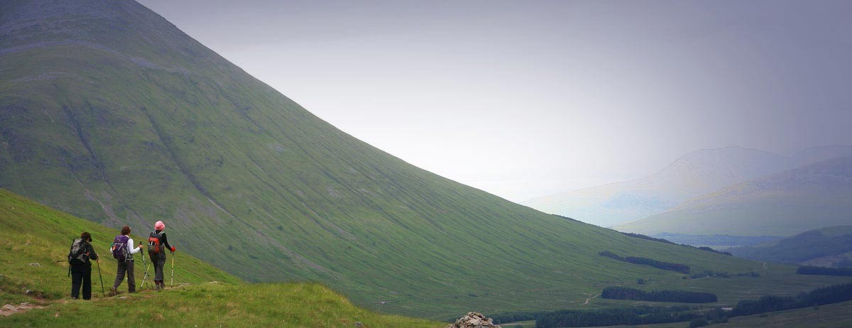
Today marks the sudden transition of the lowland route into highland territory - the 'Highland Fault', which runs near to the alignment of Conic Hill and the Loch Lomond Islands that you should see stretching out in front of you. The climax perhaps is the walk up Conic Hill (358m) which, in good weather, provides terrific views over Loch Lomond, its islands and on towards the Luss Hills. The Isle of Arran can even be viewed on a clear day. The walking is very mixed, from field to forest to fell, and then from Balmaha it is surprisingly up and down along the loch shore until the end of the stage at Rowardennan. Although Conic Hill certainly requires a little effort, some people find that the loch shore undulations later on during the day are much more draining. Still rest assured that today is one of real natural beauty.
This is the roughest and arguably the hardest section of the whole route. Although you will be walking north along the loch shore, and not climbing much more than 80m at any one time, there are a tremendous number of undulations and convolutions, especially north of Inversnaid. The route is badly eroded in sections and will offer little respite from rocks, mud and tree roots until you arrive at Inverarnan, save for the stunning loch-side scenery! After Rowardennan, there are a couple of places to take refreshment before getting to the famous Drover's Inn at Inverarnan, which is so full of old character. You could raise the ball and summon the Ardleish/Ardlui ferry to take you over to the other side of the loch for a while or to stay at the hotel there, or you could continue on into Glen Falloch.
If the march yesterday was a bit of a strain, the suggested day stage today is a lot shorter. It will take you away from Loch Lomond and north easterly, crossing the Glasgow-Fort William railway line in Glen Falloch, and then ascending through Forestry Commission plantations, from where you can drop down to Crianlarich, situated under the giant buttresses of Ben More. The village is good for a re-supply, or even a day’s rest, because now you are approximately halfway on the tour amidst mountain splendour. There is plenty to see along the way, although much of the day you will be aware of being accompanied by the road and rail arteries. There are babbling brooks and small torrents, forest glades and, if you are good with your map and have a good eye, you might even see the na Briton - a rather large boulder high above Glen Falloch, which was supposed to be the marker that divided the ancient kingdoms of the Britons, The Scots and the Picts. You should also see a few remnant pines of the Caledonian forest that used to cover much of lowland Scotland. The remaining pines now look fairly sad and incongruous on the grazed hillsides.
This is a beautiful day of glen and low-pass walking on good trails and the old military road, with some moderate gradients, but nothing too demanding. There is a choice of two routes to take you from Crianlarich, back up into the forests above Strath Fillan. Then it is down and along to the historic ruins of St. Fillans for a pause before you carry on to Tyndrum, an old mineral mining village, where you will find cafés, restaurants and shops. There follows a gradual climb up out of the village, parallel with the road and rail communications. This then passes into a classic glacier-carved 'U' shaped valley of Glen Auch/Glen Orchy. The most spectacular section is that of walking under the titan bulk of Beinn Dorain (1,076m), before reaching refreshment or accommodation at Bridge of Orchy.
This is the most exposed stage, as you will be crossing Rannoch Moor. It starts with a muddy woodland and moorland climb over Mam Carraigh, but then from Victoria Bridge near to the Inveroran Hotel, you will be back on the old military road with a reasonable surface rising to 350m on the moor. The first part of the moor is called the Black Mount, the name which it probably gets from the colour of the peat and the lochans. This is a wonderful, remote and rugged place to be, but exceptionally hostile in bad weather. There is no shelter upon Rannoch, before White Corries or Kingshouse, and accommodation is generally limited to the latter.
The Way enters some very beautiful scenery at the top of Glencoe, and then climbs out over the switch-backed Devil’s Staircase, an amazingly well-engineered and graded section of the military road, opening up great views back towards Rannoch Moor and over to the sublime peak of Buachaille Etive Mor - The Shepherd of Glencoe. The Way reaches its highest point at 500m and then descends fairly steeply down to Kinlochleven, on the sea loch of Loch Leven, under the 'Pap of Glencoe' where there is plenty of accommodation. If you have more time this is also a very nice place to stay and go climbing in the Mamores, or for scrambling along the Aeonach Eagach Ridge... if you are very fit! The beauty of the place is in the views of the great sea Loch Leven and presiding over it, The Pap of Glencoe. There are good amenities in the town.
This final stage of the Way takes you to a resolute climax overlooking the hulk of Ben Nevis, before you drop down to the end of the walk at Nevis Bridge. It is quite a long day and, despite a good mixture of forests and abandoned farmsteads, can once again be quite exposed to the elements. From Kinlochleven you will ascend quite steeply, although on good tracks, to 330m above sea level. The Way then descends from the Lairigmor pass and re-ascends through forest, and then down to Glen Nevis and Nevis Bridge where the tour officially ends. There is a full range of accommodation here and, at Fort William, with good services connecting the rest of Britain.
Click the blue 'BOOK MY LUGGAGE' button above to organise baggage transfer services.
Trains to Milngavie and from Fort William travel via Glasgow. Refer to www.nationalrail.co.uk

