A challenging route across the high country of the Yorkshire Dales, following the old packhorse road trade routes.
From Saltaire the route crosses moorlands, speckled with standing stones, some with ancient rock designs, and follows the dramatic limestone scars of Malhamdale. It meanders along the bank of the River Ribble and climbs Ingleborough of ‘Three Peak’ fame. It skirts the flanks of Whernside (optional ascent), dropping into beautiful Dentdale, before reaching Sedbergh and continuing with a breath-taking, six-mile ridge walk across the mossy folds of the Howgill Fells. The Dales High Way passes isolated Sunbiggin Tarn before dropping into the lush green of the Eden Valley to finish in Appleby. You could return via a breath-taking train ride along the Settle to Carlisle line, which takes you back past some of the landscape highlights that you have been walking through.
Click the blue 'BOOK MY LUGGAGE' button above to organise baggage transfer services.
Walkers are required to bring their own face mask and hand gel.
The Walk starts from Victoria Hall in Saltaire. This was developed as a model industrial town by the textile industrialist Titus Salt in 1850 and built in the Italianate style, with huge mills and workers’ cottages, bath houses, library, school, but only a soft drinks pub! Today it is now a well-preserved World Heritage Site. There is quite a bit of undulation across the heather moor, with its prehistoric marked stones. Leaving town up through a wooded valley, then across Rombald’s Moor, you are at the southern point of the Yorkshire Dales, by Weecher Reservoir and soon crossing the famous Ilkley Moor. Reaching 380m at the highest point today, there is a stone circle nearby called ‘The Twelve Apostles’. You then come to the Lanshaw Lad boundary stone with vistas over Wharfedale. Finally, dropping off the moors through Ilkley Crags, you reach White Wells Cottage (a Victorian Spa House), where if the flag is flying, you can get a welcome tea. Finally hobble into pretty Ilkley, originally a Roman fort town but really developed by the Anglo-Saxons, whose crosses still adorn the Parish church.
Heading back to the moors, the route passes a little waterfall (Willy Hall’s Spout), skirting the moor’s edge before gently ascending across Addingham Moor, passing the Bronze Age ‘Swastika Stone’ with its marking. Then pass by another Saxon town, Addingham, where in AD. 867 the Archbishop of York hid to escape the Vikings, and the first successful spinning mill was built in 1789. The route then follows a possibly Roman Road called ‘The Street’ to an interesting old marked milestone at Draughton Height. The way into Skipton follows an old toll road to reach the largest town of the route, known as ‘the Gateway to the Dales’, and one of the best-preserved small towns in Britain. A lot of the building occurred here in the 1650s under Lady Anne Clifford after the English Civil War. There is also an interesting canal basin in the town adjacent to the main street.
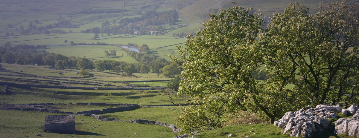
The first part of today’s route climbs up Park Hill, where the Roundheads placed a canon to pound Skipton into submission during the English Civil War. After crossing a golf course, the trail enters the Yorkshire Dales National Park and upon Flasby Moor to Sharp Haw (357m), with magnificent views. Down from the hill you follow the Hetton Beck to Hetton village. The district’s Women’s Institute was the original inspiration for the film ‘Calendar Girls’. Next it is up via the Winterburn Reservoir, across moors to Weets Top (414m), from where you can appreciate the transition between gritstone moorland and craggy limestone ahead. From here there are views of Gordale Scar and Ingleborough Peak, before descending into attractive Malham Village, or you can bypass it directly heading to Malham Cove. Both this and Gordale Scar, with their limestone cave and waterfalls, are two of the premier Dales attractions.
Leaving Malham Cove, you enter a dry limestone valley (a river submerged millennia ago), lined by the Ing Scar Crag and then you climb up a rocky stairway and over Langscar to the restored Nappa Cross at the foot of Grizedales Crags, on the flank of Kirkby Fell. The view back is to Malham Tarn and Pen-y-ghent. You can make a short detour up Kirkby Fell to appreciate the aspect of the Craven Fault – an ancient earthquake zone which was responsible for the crustal shifts that have resulted in today’s landscape. The path swings round under Attermire Scar, where in the 1840s an array of Roman and prehistoric artefacts were found in the local caves. By Warrendale Knotts you look down towards Settle and you may be able to make out the southern lakeland peaks. The trail then heads directly into Settle, another attractive market town with a range of accommodation. Continuing on the way, you cross the River Ribble towards Giggleswick and follows this delightful river all the way to Stainforth Bridge, by an impressive little cataract and then into Stainforth.
Leaving the Ribble, you pass Smearset Scar with its prehistoric walling, possibly marking burial sites, and then descend to the hamlet of Feizor. After a mixture of gates and stiles leading through a number of fields, the way goes through Wharfe, heading out to Crummack on a bridleway, passing the pretty limestone slab-built Clapper Bridge, which is next door to the Wash Dub field, where the stream was dammed on occasion to create a pool for sheep dipping. From Crummack the terrain gets bleaker, and care is needed over limestone pavements and in taking the correct paths, especially in low visibility and bad weather. There is an alternative bad weather route via Selside to Ribble Head and Chapel-Le-Dale. However, the main route joins the famous Three Peaks Track and ascends the breast of Simon Fell, up a steep stone stairway to Ingleborough (724m). This was the site of a vast Brigantes (Iron Age tribe) fortress. Although due to the harsh climate, it is now wondered whether the site was not some older Bronze Age religious site. You need to be careful of the steep stony descent in wet or misty conditions. Walking through the Ingleborough Nature Reserve, with walkways to protect the landscape, you pass a series of limestone scarps to reach the village of Chapel-le-Dale. Here we find St. Leonard’s Church, home to the remains of over 200 labourers and their families who worked upon the Settle to Carlisle Railway from 1870 to 1877. Note that there is an alternative route from Ingleborough Peak to Ribblehead via Park Fell.
The whole walk today follows a packhorse trail known as the Craven Way. When you get to Bruntscar farm / hamlet there is an alternative (in good weather) up to Whernside (736m), the highest of the Three Peaks. On the way down you visit the pretty Whernside Tarn. The standard route however, via Ivescar with great views of the famous Ribble Head viaduct, reaches the old signal box at Blea Moor Sidings. The two paths meet again at Wolds End. Then with views opening up of the Howgill range in Cumbria, the trail descends to Deepdale and via numerous stiles to Dent in Dentdale. This was the most important market town of the area, with at least 30 shops in the main street and very much associated with wool and wool knitting. Today it is a much quieter place with quaint cobbled streets, one shop and a couple of pubs. Perhaps only the large 12th century St. Andrews Church hints at the past wealth of the town. This was also the birthplace in 1785 of the famed geologist Adam Sedgwick. One of his students was a certain Charles Darwin. Out of Dent the route follows The Dales Way for a while, across Barth Bridge and across Long Moor towards Longstone fell, alongside the boggy Holebeck Gill. Finally, a walled lane brings you across New Bridge and up into the town centre of Sedbergh at the foot of the Howgills. This attractive 13th century market town, with its old-world atmosphere, has developed at the confluence of four rivers, where ancient trade routes merged - a staging point for commercial routes across the Pennines dating from Saxon times. The town is full of character, from its cobbled streets to its historic houses, some of which show the hallmarks of the old knitting and woollen trades which made the area such a thriving community. It is famous for its public school, set in magnificent parkland on the edge of the town. There is a fine Norman church, George Fox, founder of the Quakers, preached here, and overlooking the town is the site of Castlehaw, an ancient motte and bailey castle built to repel the Scottish hordes. After the 2001 foot & mouth disease outbreak, the Sedbergh booktown project was started in order to encourage visitors to the town. A company was set up in 2003 to develop a community of businesses involved in selling, writing, publishing and designing books and other publications.
Brace yourselves for a 6-mile Howgill ridge walk today, starting with a steep ascent. Hopefully it will be clear so that when you reach ‘The Calf’ (676m) you will be in a position to appreciate the views of the Pennine Hills, such as Wild Boar Fell, Cross Fell, the Orton Fells and Sunbiggen Tarn. Then there’s the Lakeland fell skyline and back towards The Three Peaks, from whence you have come! Watch out for the feral ponies that roam around the hills all year. You will notice that there are no drystone walls up here - The Howgills missed out on the enclosure acts from the 1750s which packaged up a fifth of England for rich landowners away from commoners. There is a poor weather route down to Bowderdale from ‘The Calf’, but the main route continues over Hazelgill Knott then up West Fell and then down to Newbiggen-on-Lune. If the weather is bad when you actually leave Sedbergh there is a bad weather route following the River Rawthey. Newbiggen-on-Lune, set on the northern edge of the Howgill Fells in limestone country, gets its name from the River Lune that runs through the valley on its way to Lancaster. The community’s main activity is farming fell sheep. Stone buildings, a Methodist chapel dating from the early 1800s, the church of St Aidan, a village hall, a plant nursery and a number of accommodations add to the village mix. Fishing for trout in the river is a popular sport.
Following the Great Asby road out of the village, the trail soon turns off across Ravenstonedale and around the bird watcher’s paradise of Sunbiggen Tarn, familiar with anyone who has done The Coast to Coast. From Tarn Moor you follow wall lines up over Great Kinmond with great views, before dropping down through Clockeld Farm onto a lane into Great Asby. Follow a minor road to Howe Slacks then follow Scale Beck to Rutter Force waterfall and associated mill. The trail then follows The Hoff Beck to the hamlet of Hoff and onwards to Bandley Bridge. Crossing over stiles you then climb away from the Beck passing over fields and at the top of a hill you will see Appleby Castle with the Pennines in the background. An enclosed lane brings one out at the walls around Appleby Castle and you enter Appleby by the High Cross at the top of Boroughgate. Appleby is at the heart of the lush Eden Valley and is one of the loveliest towns in the north of England. It was transferred from Scotland to England in 1092, but continued to suffer attacks from the Scots and was all but destroyed in 1388. The picturesque street of Boroughgate, with some interesting old buildings, is at the heart of the town and links the well-preserved Norman Castle with the fine medieval Church of St. Lawrence. The castle is a motte and bailey type of the 12th century, the eastern part was re-built in the mid-fifteenth century by Lord Clifford and later in the seventeenth century, restored by Lady Anne Clifford. You can see Lady Anne's tomb in the parish church of St. Lawrence. Visit Appleby in June and experience the atmosphere of the three-hundred-year-old Horse Fair. Traditionally the fair was an annual event where Gypsies gathered to sell their horses, also a meeting place where they congregated from all over the country.
Click the blue 'BOOK MY LUGGAGE' button above to organise baggage transfer services.
Train to Leeds and change for a service to Shipley and Saltaire. Staying in Shipley, Saltaire is a 20 min walk or 2 min taxi ride. Returning from Appleby connect via Leeds to other major cities within the UK. Refer to www.nationalrail.co.uk

