The first official National Trail to be created in the UK – 268 miles of heathlands, limestone cliffs and challenging, high peaks.
2023 SEASON: Please note, the last bag collection from Edale will be 8 October 2023
Book your full Pennine Way package now.
If you have any queries, please email info@sherpavan.com.
Some say, after they have been swimming through the bogs of Kinder Scout or Cheviot, they could see why such a concession for a footpath was given for the route. In reality the trail being a popular ‘tester’ has attracted a great deal of attention from walkers.
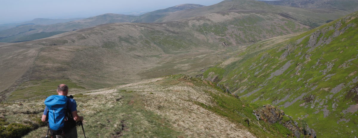
While the National Park authorities try to improve trail conditions, it should be made clear that this walk passes through some of the loneliest and loveliest high walking terrain in England, and over such length that there is a tremendous variety from high peat bog, heathlands, beautiful karst (limestone scenery) including cliffs, caves and rock pavements. There are also big peaks known as the High Fells, of which Cross Fell is the highest point at nearly 3,000 feet; the smaller hills of the Yorkshire Dales. There are also deep green valleys such as Swaledale, with beautiful rivers, and tremendous natural features such as High, Low Force waterfalls and High Cup Nick - a glacial valley. You’ll also get to visit the highest pub in England at Tan Hill.
Most people walk the Pennine Way from south to north, which usually means that you are walking with your back to the worst of the weather, and most walk it in 2-3 weeks. Maps and compass are essential as there is limited waymarking en route.
Click the blue 'BOOK MY LUGGAGE' button above to organise baggage transfer services.
Walkers are required to bring their own face mask and hand gel.
The First day and a tough one with a high degree of undulation. The route has changed over the years. It used to go right over the top of Kinder Scout, where many people proceeded to get lost in both good and bad weather and in the bogs and peat hags of the mountain. The modern route is a lot easier and safer in the sense that you are kept off the tops of Kinder Scout and kept to a generally good path up over Jacobs Ladder, Kinder Low and up towards Kinder Downfall the main drainage from the massif which often blows uphill when it is windy! The way then descends from Kinder and along a long section of paved walkway from Mill Hill crossing the A57 road and up to very bleak Bleaklow head before a long and, in places, steep descent via Torside Clough to Torside reservoir. The nearest accommodation to Torside is located in Crowden.
A fairly straight forward day passing several small to medium sized reservoirs.The walk crosses Torside Reservoir before before striking North steeply above the Crowden Brook. There are some beautiful view points as you ascend among sandstone rocks and along the edges of Rakes and Laddow Rocks. Eventually from the rock edges you descend to make a number of stream crossings along Meadowgrain Clough and then up over Black Hill.The summit marks the border between Derbyshire and West Yorkshire. The path descends on the stones down to the busy A 635 road which you cross and connects with a series of gravel and grassy tracks. There is a steep rough climb beside Blakey Clough and then sections of grass and stone pavement passing Swellands and Black Moss Reservoir until you reach Standedge where there is a railway and canal tunnel. The nearest accommodation to Standedge is located in Marsden, Diggle or Delph.
The walk continues up alongside a series of edges and Moorland hills with views over towards the large urban conurbations around Oldham and Manchester. After a brief dalliance on an ancient packhorse road, the Pennine Way passes three reservoirs before winding up to the needle shaped Stoodley Pike monument that you can see over 5 miles before you reach it. This is a classic viewpoint along the route. There follows a long descent into Hebden Bridge.
Initially a steep climb, but soon you are back on the trail and heading up to Colden where you can have a pint of tea at ’May’s Shop’, Highgate Farm. The trail then crosses the moors of Clough Head Hill descending on good tracks past Gorple lower reservoir and then on past two Walshaw Dean Reservoirs to ascend Withens Height end and slightly down to Top Withens. The way then gradually descends through farms to Ponden reservoir past Ponden Hall. From Ponden a steep climb follows over Old Bess Hill and over Ickornshaw Moor on good tracks passing little black huts called ‘Cowlings’.
This bridging day takes you between the end of the grit stone peat bogs and brighter limestone scenery for a while. Today you pass through some attractive more lowland rolling countryside, passing the pretty village of Lothersdale and then a short section beside the Leeds and Liverpool canal. Now in the Craven valley the geology begins to change to limestone after Gargrave, and you follow the River Aire towards the popular tourist hotspot of Malham.
Now you are in the Yorkshire Dales National Park, and you will climb steeply up the cliffs of Malham Cove to walk along the limestone pavements into Watlowes Valley. Eventually you should get to beautiful Malham Tarn. After Fountain Fell the whale back like hump of your high point for today can be seen. This is the peak of Pen-y-ghent (2,277ft / 694m) which is well known to walkers of the Three Peaks Walk. As you go over the fence on the top of the hill, you may meet a lot of people sheltering in the lee of the fence with their packed lunches, huddled in the wind and rain or worse. The downhill route to Horton in Ribbleside is quite clear, passing Tarn Bar en route, a tiny version of Malham Cove. At the B6479 road you will find it hard to resist the temptation to visit the Pen-y-ghent café to sign the book for Pennine Way walkers. It is best to top up with lunch supplies here for tomorrow, because there is little en route.
Up through Birkwith Moor, with impressive dales scenery once again. And it is worth trying to locate the stream tumbling into Calf Holes Cave only to reappear a bit further on at Brown Gill Cave. The route eventually climbs to join the Roman High Road at Cam End and then intersects with The Dales Way, which possibly is the most popular long-distance footpath in Britain. The walk edges around Dodd Fell before dropping down through farmlands to the village of Gayle and on to the bustling town of Hawes on the A684.
A mile up the road you will be able to visit Hardraw village, home of England's highest waterfall, Hardraw Force. It is then time to leave the green fields of the valley for desolate moors up to Great Shunner Fell before descending to the fields of Thwaite, the arrival of whose cafés are just in time for a pleasant lunch spot. There then follows a very beautiful section where the walk climbs high above the River Swale, meeting The Coast to Coast for a while. It is possible to walk an hour or so off route to Keld for additional accommodation, otherwise it means blasting on the trail a bit further up the moors to the Tan Hill, about 4 miles from Keld, which at 528m is a welcome site, being the highest pub in England, and is the only place around here offering accommodation.
Another nice day is spent leaving the Yorkshire Dales National Park and entering the Area of Outstanding Natural Beauty called the North Pennines. This is often a stage where compasses come out! From Keld, blast onto the moors again and a bit further up you will reach Tan Hill, about 4 miles from Keld which at 528m is the highest pub in England. After the pub, walking along Sleightholme Moor for a few miles can be very misty and muddy. Especially if you stayed last night in Keld you will probably be dropping down to Bowes or Baldersdale for accommodation, pubs and shops tonight. Otherwise the trail divides at Trough Heads and you will cross the River Greta via a slab of stone: ‘God's Bridge’ and underpass the busy A66, before continuing on through the moors to Blackton Bridge YHA, thus avoiding Bowes. If you stay at Bowes you will pass Blackton tomorrow.
A nice bleak moorland and stream walk to Middleton in Teesdale today, which could take 6 hours or so on rolling terrain, with no big ascents. There is a lot of stone walling around, many farms, ruins and the reservoirs of Blackton and Lunedale before the route passes Harter Fell and drops down into the valley of the river Tees. The Youth Hostel at Blackton is thought of as being the halfway point of the route. Please note that those walking Bowes to Langton Beck will need to spend another day walking from Langdon Beck to Dufton (12.5 miles), otherwise the hike over to Garrigill becomes 28 miles. The nearest accommodation to Langdon Beck is located in Forest-In-Teesdale.
Be prepared today because you will encounter some of the wildest natural features of the entire walk. There are some opportunities for lunch en route. Leave Middleton with enough supplies along the course of the River Tees which will resemble malt whiskey in colour. The first waterfall is called Low Force and drops over a series of rocky steps. Eventually you reach the outstanding High Force. If you are hostelling, you may stay at The Langdon Beck YHA a bit further on. If you are continuing you will reach another waterfall called Cauldron Snout, rumbling on the Tees. Follow the moors along the Maize Beck until you reach High Cup Nick, a deeply cut glacial u-shaped valley. Then it is on a few miles downhill to Dufton.
A full, long day, so carry enough food with you. It is certainly the hardest day that you have encountered so far with regard to route finding if the weather is poor. From Dufton the route takes you up over Knock Fell (794m), Great Dun Fell (848m) with its 'Golf Ball ' radar, over Little Dun Fell and then Cross Fell (893) which is the highest point along The Pennine Way. The moorlands here are no place to get lost in the mist! There is a mountain refuge a little further on if you need it. It is then a tiring march to the metalled road at Garrigal for pub refreshments or for the night, but if you have got the time it is recommended that you walk the 2 miles or so along the South Tyne to the pretty little market town of Alston.
Some may find this section a little tedious. It is very agricultural and can be very muddy in places if there has been a lot of rain, and perhaps the name of the village of Slaggyford sums it all up! You then take the Maiden Way Roman Road towards Hartleyburn Common and onto Greenhead.
Hadrian’s Wall and the Northumberland National Park beckon on the route. Walking the rollercoaster of Hadrian’s Wall is tiring and we recommend staying at Once Brewed, giving you plenty of time to visit the major attractions along the wall today. There are cafés (seasonal) en route. Walking along the Cawfield and Winshield crags section the wall is very well preserved. You then drop down to pub and hostel at Once Brewed. If you are staying at the youth hostel here tonight, we recommend that you drop your things there and continue along the wall to see a lot more of it at your leisure, as the route turns to the North at Cuddy's Crags before the Housesteads section.
Head easterly along the wall for a few miles, (you may want to detour to see Housesteads Roman Fort if you did not go and see it yesterday). This section from Steel Rigg is the most dramatic of the way, but very exposed on a cold blustery day. You should get great views to the Pennines and across to the Simonside hills in Northumberland and the various coniferous forest estates. After this you turn north into the Northumberland National Park and through the coniferous Wark Forest and to Lowstead, a fortified house to protect the locals and their animals from raiding groups called Reivers. The walk follows small roads and crosses farmland and the North Tyne to follow the river bank down into the pretty village of Bellingham, just about the best place to stock up with basic supplies until the end of the route.
You will need to carry all your supplies for the day with you, as you cross several miles of heather moorlands before passing through more conifer forests, then between forests and moors, and then back into the forest and via Blakehopeburnhaugh on a nice riverside path to the village of Byrness, which has limited accommodation possibilities due to its nature originally as a Forestry Commission station, rather than a market town.
The longest day provides the ultimate climax to the walk, and it is likely to take you all day as well. In addition, there is the detour up to the big boggy fell of Cheviot (815) which will add slightly to the distance. Be prepared, it is a hard, long walk and pretty lonely. You must be ready to navigate. 'The Way' climbs over Moorland, with an alternative route to take in Chew Green Roman Camp. Eventually you drop down across the Cheviot Fells to alight at Kirk Yetholm, an old borders market village in the middle of nowhere in particular, but just happens to be the end of the Pennine Way.
Most walkers choose to split this into 2 stages. Byrness to Kirk Yetholm is charged as a 2-day stage.
Click the blue 'BOOK MY LUGGAGE' button above to organise baggage transfer services.
Edale is easily accessed via trains from Sheffield. From Kirk Yetholm you need to catch a bus to Kelso or taxi from where you then connect with a bus to Edinbrugh or Berwick Upon Tweed to connect to train services. Refer to www.nationalrail.co.uk

