Cycle from the lighthouse at the port of Whitehaven on the Irish Sea coast to the lighthouse at Sunderland on the shores of the North Sea.
Book your full C2C Cycle Route package now. If you have any queries, please email info@sherpavan.com.
The ‘C2C’ stretches for 140 miles / 230km from the harbour at Whitehaven on the Irish Sea to the Abbey and castle at Tynemouth on the shores of the North Sea. Almost all of the route is based on minor roads and cycle paths, so that the cycling can be enjoyed to the full without worrying about traffic. Four days cycling will cover the journey, but you may want to linger and enjoy the sites and scenery along the route more fully, in which case six days affords a fairly leisurely outing. There are many points of interest on, or near, the trail that merit a detour - not least the beautiful cathedral city of Durham.
Handelbar level is a great way to see northern England and how the landscape changes sometimes abruptly, and then more gently as you cycle along. Take in the Cumbrian Lakes and Fells, the bleak Pennines, beautiful Dales, towns and villages of all sizes. There are some quite big hills as well, but nothing that could be classed as Alpine! the weather of course can do anything, but you will generally be pedaling with the wind at your back.
Our vans provide daily baggage deliveries between hotels, B&Bs, and campsites along the whole length of the C2C trail. Most cyclists take advantage of the prevailing winds and travel from west to east.
Click the blue 'BOOK MY LUGGAGE' button above to organise baggage transfer services.
Cyclists are required to bring their own face mask and hand gel.
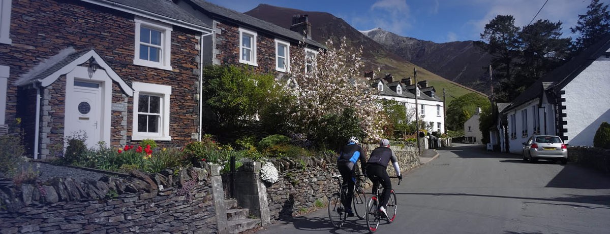
From Whitehaven to Rowrah the route is mainly on the Sustrans Ennerdale Railway path. Along this section there is a sculpture trail which interprets the geology and industrial history of the region. From here it's on to minor roads up to Loweswater. The climb up from Lorton to Whinlatter Pass is the first big test. The Whinlatter Visitor Centre at the top does food in season - it can be a welcome rest and shelter. The centre is in the midst of the mountain forest and contains a wealth of local habitat information. The route continues on forest tracks to Thornthwaite, and then follows minor roads to Keswick.
This stage of the route in the Vale of Eden is an easy ride of ever-changing scenery. You will follow minor roads - out of the centre of Keswick the road climbs steeply past Castlerigg Stone Circle and then passes through the village of Threlkeld. You will need to go down some steps and cross the A66 to continue on your way to Troutbeck, where you will need to cross the A66 once more. Continue through Greystoke and the market town of Penrith - after crossing the River Eden you will reach Langwathby. There is an alternative route along the Old Coach Road which leaves the main route at Castlerigg Stone Circle, and follows a steep, rough track over Threlkeld Common to Matterdale End. This alternative re-joins the main route at Greystoke.
The most mountainous section of the entire route, this stage contains four major hills within twenty miles. Climb steeply out of Langwathby to reach the Little Meg Stone Circle, continue on minor roads and then on to a stony track, join the A686, a tarmac road, and follow it to the first and the steepest hill, Hartside, which is also the watershed between the Irish and North seas. After Hartside, continue through the villages of Leadgate and Garrigill. From the centre of Garrigill continue along the south side of the River South Tyne, before crossing it by a ford. A steep uphill track will take you to Priorsdale, from where the route descends steeply through old lead mines to Nenthead. After Nenthead you reach Black Hill, the highest point on the C2C. The stage ends by descending into the valley of the River East Allen and the village of Allenheads.
Marking the end of the rough, hilly terrain of the Northern Pennines, this stage marks the start of the industrial landscape of the North East. There’s a steady climb out of Allenheads until you reach the summit at Currick, which is followed by the long, more gentle descent down the Rookhope Valley. Scars from centuries of lead mining are evident in the valley. The route leaves the road in Rookhope village and climbs steeply up the old railway incline - from here the route follows rough tracks and paths until it reaches Waskerley. (This section of the route will be closed occasionally during the shooting season, when alternative routes must be used). Follow the Waskerley Way, a reclaimed railway path - you will cross the Hownsgill viaduct, and then continue on the Consett and Sunderland Railway Path, passing through Consett, Leadgate, and Annfield Plain. Continuing to Stanley you will pass several sculptures on the way.
This stage is one of the easiest on the C2C - with the exception of one small climb at Cox Green it is all downhill or flat, allowing plenty of time to enjoy the changing scenery, from the rolling hills of Beamish to the industry of Sunderland. From Stanley continue along the Consett and Sunderland Railway Path, past Beamish, Pelton and Washington. Along the route there are access points at most road crossings allowing the towns to be visited, to explore and use facilities. There are several sculptures, part of a sculpture trail stretching from Consett to Chester-le-Street. From Washington, continue through James Steel Park and cross the River Wear, there is then a steep climb on the way to Pallon. In the final section you will follow the path alongside the River Wear, past the marina to reach the North Sea at Roker.
Click the blue 'BOOK MY LUGGAGE' button above to organise baggage transfer services.
Whitehaven has a train station with regular services on either the Carlisle – Barrow line or the Manchester Airport - Lancaster - Barrow line. From London Euston there are regular trains changing at Lancaster or Carlisle. Mainline rail services from Tynemouth run via Newcastle from where you can catch trains throughout the country. Refer to www.nationalrail.co.uk
Manchester is your closest major airport. You can catch the train to Lancaster where you change trains for Whitehaven. If you are flying into London, you’ll need to get the tube or train to London Euston, where you can catch the train to Whitehaven changing at either Lancaster or Carlisle.
At the end of your cycle, mainline rail services from Tynemouth run via Newcastle where you can catch trains to other major centres.

