Rich in historical interest, the Cleveland Way encompasses 110 miles of rolling moorlands, dramatic cliffs and sandy beaches.
Book your full Cleveland Way package now.
If you have any queries, please email info@sherpavan.com.
The route of the Cleveland Way is punctuated at intervals with interesting market and fishing towns, steeped in history and literary association. The walk must not be underestimated, as there are plenty of ascents and descents, and it traverses over high moorland with some steep climbing.
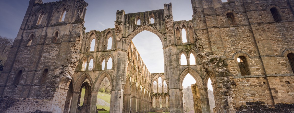
Highlights of the Cleveland Way include the remains of the Norman Rievaulx Abbey, Whitby Abbey (with its connections to Bram Stoker’s novel, Dracula), the Captain Cook Monument, and Robin Hoods Bay with its cliff-hanging cottages.
Click the blue 'BOOK MY LUGGAGE' button above to organise baggage transfer services.
Walkers are required to bring their own face mask and hand gel.
After your arrival in Helmsley, if you have not overnighted here, it is certainly worth a look around, and additional information on the walk and the North York Moors National Park can be obtained from the National Park HQ in The Old Vicarage, Bondgate. Today is fairly easy so you could start at lunchtime from Helmsley's Market Square and include a look at Rievaulx Abbey, which is about a half mile detour, and you could also walk another detour to visit The White Horse of Kilburn, a limestone horse created by removing turf from down land. The ‘Big Peak’ of the day is the climb up to Hambleton Hill, about 700 feet of ascent from Nettledale. There are several hamlets at around 10 miles where you could stay for your first night, such as Sutton Bank, Cold Kirby, Hambleton or Kilburn.
Today is a walk at around 1,000 feet along the Hambleton Hills from Sutton Bank / Kilburn. If you have stayed the night in Kilburn you will have a steep climb up to regain the height you lost. You travel today along the western edge of the National Park itself on drove roads steeped in history. You will pass by many tumuli (grave mounds) and over moorland, climbing up to Hambleton End at 1,309 feet, the high point of the day. There are great views from the ridge, but little scope for refreshment until you drop down to Osmotherley with its quaint shops, cafés and pubs. So remember to take a packed lunch with you! Osmotherley itself is a fine old market town which grew as a green village at a road junction. There is a Youth Hostel and altogether it is a fine place to stop.
This section is said to be the most strenuous of the tour, a rollercoaster of a walk up and down the Cleveland Hills, including the best walking within the park. You should have some excellent views once again to the agricultural plains to the north west, and the moors to the south east. You should bring all your own rations today, as there are few stops en-route. Much of the accommodation is off route and you may want to ask if you can have a lift back to where you can regain the route.
A shorter day today, but you still have to climb up to the summit of Urra Moor and Round Hill, which, at 1,489 feet, is the high point of this journey. The moors can be pretty windswept and cold on occasion, but there are wide sandy paths worn into the hillsides between the grousey fields of heather to make good progress on. These can be boggy in places, despite the sand, and there have been some counter erosion remedies in place such as flagstones that can be hard on the feet at times. From Tidy Brown Hill you descend into the village of Kildale where you can find accommodation, either there or a couple of miles away.
An interesting day's walk, as you head down to the coast at Saltburn and the walk begins to take on a different character to the woody scarps and open moors that you have been used to up to now. First the route climbs up Easby Moor to visit Captain Cook's memorial (he was born nearby), with the opportunity to detour by about a mile to climb the eroded sand stone stump of Roseberry Topping, then skirts around the town of Guisborough and through the farming settlements of Slapewath and Skelton, before meandering down with the Skelton Beck to the sandy seaside town of Saltburn-by-the-Sea, and the prospects of a good ice cream and fish and chips. It is a pretty place, thoroughly re-organised by the Victorians, but you can still sense the old days of smuggling and crime rackets. If you are only doing half the walk, there are rail connections from here to Middlesbrough.
Today is quite an easy walk along the coast to Staithes (pronounced ‘Stairs’ locally), although there are a couple of stiff climbs up to Hunt Cliff and Micklow Hill at around 1,000 feet. Your second cliff at Boulby is the highest on the east coast of England. In between the hills you drop down once again to sea level, losing all the height you have gained but at least there is the chance of an ice cream stop. Walkers should be aware of the cliff edges where the path largely runs - it may be undercut in places and is prone to erosion. Also, be careful of the cliff edges in strong winds. There is a lot of accommodation en-route today, and some folk might prefer to walk on to Ravenscar to stay the night. However, we do recommend that you spend a substantial amount of time (if not overnight) in the beautiful and largely untouched fishing village of Staithes, and discover the old coastal Yorkshire with its fleet of fishing cobles (flat-hulled, sharp-prowed fishing boats, said to have come from Viking design) in the harbour.
A second fine day of coastal walking along the cliff tops over to Runswick Bay and then Sandsend, past more historical mineral workings, until you reach the long sandy Upgang Beach, which stretches over 3 miles to Whitby Sands and probably the most special town along the route - Whitby Bay. This is a popular tourist destination and boasts of having the best fish and chips in the British Isles. The town has some fine buildings, and there is a variety of accommodation, including a Youth Hostel up by the famous Whitby Abbey.
A shorter day is recommended here today because there is so much to see and enjoy in these two famous towns. They are both steeped in history, not just the fishing and the smuggling, but in Whitby you have a religious background, and at Robin Hood’s Bay you have a slightly obscure historical legend concerning a particular man who the town is named after! In between the towns there is walking over the brooding hill cliffs of Whitestone Point, with little beaches and even some small waterfalls approaching Robin Hood’s Bay. For the last part of the walk you may meet up with some Coast to Coast walkers, and can compare the two walks. The towns are very busy during the holiday season, but there is quite a lot of accommodation about.
To make up for the fairly short walks of the previous 2 days, today is real hike into the major Yorkshire resort of Scarborough. Like it or not, all the funfair and ice cream kitsch is an important part of British holiday life and has been exported all over the world in various guises. The walking involves a coastal rollercoaster of sea cliff paths, staying very close to the edge for much of the time. Altogether there is about 1,300 feet of total ascent over the 15 miles. There are limited refreshments en-route, and some interesting coastal feature names, such as Dab Dumps, Boggle Hole, Beast Cliff and Sailor's Grave. Today's is a brooding, lonely, lovely walk.
The final stage, with only about 500 feet of ascent to go. Out of the bustle of Scarborough the route takes you out along the esplanade and the golf course to Cayton Bay. You should have time to visit the old castle and the spa complex. The walk then hugs the cliff quite closely before reaching its official end at a style at milepost 103. Most people carry onto Filey and end at the North Cliff Country Park, Filey Brigg. Congratulations – you’ve completed the Cleveland Way!
Click the blue 'BOOK MY LUGGAGE' button above to organise baggage transfer services.
Helmsley, at the start of the route has no railway station. The closest station is Malton, 16 miles away, which is also convenient as it has a reasonable bus service to Helmsley. There is Thirsk station 17 miles away, and a limited bus service. At the end of the tour you can leave from either Filey station or from Scarborough, which has good connections via York. Refer to www.nationalrail.co.uk
Bus services run to Helmsley from Malton, via a change at Pickering. At the end of the walk there are bus services from Filey to Scarborough where you can then catch mainline trains to your onward destination. Refer to www.traveline.info
Helmsley is close to York on the A170, and is well sign-posted from York's large ring road. At Helmsley there is a car park on the north side of the town, at the start of the Cleveland Way and a weekly parking ticket is available from Helmsley Tourist Information Centre in the market place. You will be able to return to your car in Helmsley using the bus from Filey via Scarborough. If you are leaving the car for more than a week, then contact Helmsley Police Station on 01439 70310 if you cannot get through then please contact the larger Malton Police Station on 01653 692424. They will need your vehicle's particular details, so that they are aware of it.
Leeds Bradford is the closest airport, with a bus to Leeds, and rail connections to York and onwards. But if you are travelling from a London airport, you can take the train from London Kings Cross to York, and from there you can take a bus to Helmsley. You can also fly to Manchester Airport. From where you can take a train to York.

