Traverse more than 100 miles of unspoiled countryside, from the Scottish borders to the island of Lindisfarne in Northumberland.
Book your full St Cuthbert's Way package now.
If you have any queries, please email info@sherpavan.com.
The route includes a variety of delightful and quite unspoilt countryside - the Tweed valley (origin of the famous woollen cloth), the Eildon Hills, the Cheviot Hills (origin of one of the most famous breeds of sheep), and the Northumberland coast with its broad horizons, sandy beaches, and dramatic contrasts between high and low tide.
The small historic towns en route - Melrose, Jedburgh and Wooler - are equally unspoilt and offer a pleasant contrast with the thinly populated countryside. There is an abundance of historical remains including ruined abbeys at Melrose, Jedburgh and Lindisfarne. The standard route is intended to be walkable in 4 long days, but several modifications can be made to make the average length of day shorter. A second night spent in Melrose enables the intervening day to be spent on a circular walk over the Eildon hills and back along the banks of the Tweed. A short detour enables you to spend a night in Jedburgh, and a night on Lindisfarne. With Sherpa Van it is possible to extend the tour back on the mainland to the beautiful village of Bamburgh, overlooked by its grand castle before following the coast to end finally near Craster.
Most important however is to plan the route so that you cross onto Lindisfarne, and leave it, when there are favourable low tides. Tide time can be found online here.
Click the blue 'BOOK MY LUGGAGE' button above to organise baggage transfer services.
Walkers are required to bring their own face mask and hand gel.
The first day may come as a sharp shock for those who are not yet used to walking - it's just about the longest walk of the route). You have the ascent between the Eildon Hills (climbing one of them is recommended) as an appropriate warm up, before walking along by the Tweed. A visit to Dryburgh Abbey is a possibility. Soon after the pretty village of Maxton you join the Roman Road at Dere Street, which takes you near to the Harestanes Visitor Centre, where a cup of tea may be in order. Due to limited accommodation in the area it may be worthwhile to walk the extension (off route) into Jedburgh.
Either walk or take a taxi back to the point that you left yesterday, whether it is Harestanes, Dere Street or Jedburgh Bridge. Today's undulating walk takes you past the ancestral home of the Kerrs, over the highest point on the route at Wideopen Hill and down to the interesting Cheviot town of Kirk Yetholm (which is also the finishing point of the Pennine Way).
It is time to cross over into England and leave the hills for the start of the rolling lands of Northumberland. This is a great scenic walk, ending up at the old English market town of Wooler. Please note that there are no refreshments available en route between Kirk Yetholm and Wooler, and please be prepared in case of bad weather.
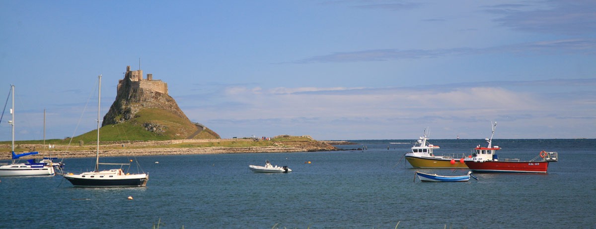
An interesting day full of variety and beauty, taking you up for the last time onto the Northumberland moors, up to St. Cuthbert's Cave, through woods and then down to the sea, reaching the Lindisfarne Causeway to take you over to the island. You’ll need to check the tide times for safe crossings. Safe crossing times are also displayed in the car park. You should be familiar with these before you start the walk, and the dates should coincide with days when the tides are in your favour. It will then be safe to follow the causeway road onto the island. The road takes the shortest route to the island, crossing the bridge over South Low, then over the sands to the Snook, the Western end of the island. It then keeps to the edge of the dunes to Chare Ends, the entrance to Holy Island Village. During high winds, blown sand will really sting exposed legs, and make sure that cameras/binoculars are well protected. The old Pilgrim's route, marked by a line of poles, crosses the sands directly from the bridge to Chare Ends. If you intend to use the Pilgrim's path across the sands to reach or return from the island, beware that the sands are covered by water for a much longer period than the causeway. You should aim to cross during the middle of the safe period to avoid deep water on the route. You should cross barefoot or with sandals, as water remains on the sands even at low tide. Join the Pilgrim's route after crossing the bridge over South Low, taking a line from the refuge box, following the series of posts going due east following terra (fairly) firma over the sand flats. (The pilgrim's route from the refuge box, is 2 miles / 3.5 km to the island, so if you are pressed for time it is better to err on the side of caution and take the road across. Do not be tempted to stray far from the posts, in case of quicksands.
(Please note that there are no more waymarks on this extension once you are off the islands - look for footpath signs instead, and stay close to the coastline, on roads, paths and footpaths, some of which are owned by the National Trust. If you do want to do the extension, hopefully you will also have your timings correct for re-crossing back from the island to the mainland again. It is an excellent day for bird-watching at certain times of the year. The walking is almost flat, and depending on the tides you could complete a lot of it walking along the beach. The best viewing opportunities are on the Fenham Flats, and the Budle Bay Nature Reserve. Bamburgh itself is one of the most dramatic and romantic castles in the country, sitting on a crag on the beach. There is a museum here, a couple of pubs and the remains of a friary.
Today you must decide whether or not you are going to do the walk to Craster, via the dramatic castle of Dunstanburgh (it is quite a short walking day) or whether you are going to go to Seahouses and do a boat trip. Timing the day's events is critical as the boat trip to the Farne Islands is governed by the tides.
Click the blue 'BOOK MY LUGGAGE' button above to organise baggage transfer services.
Mainline trains run from London Kings Cross to Berwick upon Tweed. If travelling from London or the south, recommend a night in Edinburgh and then travel to Melrose the next day to break up the journey. From here you need to catch the bus to Melrose. At the end of the walk from Holy Island catch a taxi to Berwick to connect to mainline rail services. From Bamburgh or Craster, catch a taxi to Alnmouth for trains to major cities. Refer to www.nationalrail.co.uk and www.perrymansbuses.co.uk
Edinburgh is the closest airport to the start of the walk.

