Starting in Wallsend, Hadrian’s Wall is the most important monument built by the Romans in Britain.
IMPORTANT NOTE, AUGUST 2023
The Hadrian's Wall East and Hadrian's Wall West routes are at full capacity until 16th September 2023. Unfortunately we are unable to accept any baggage transfer bookings before this date.
Although much of the wall has since disappeared, what is left of Hadrian's Wall is often spectacular, especially where it follows the uplands in the Northumberland National Park. The wall is also a UNESCO World Heritage Site and an 84-mile UK National Trail. It is therefore possible to follow the remains of the wall for the whole length of the way, even through the built-up areas at either end.
Another thing worth contemplating is the fact that for 22 miles between Heddon-on-the-Wall and Milecastle 33, the route stays beside the fairly busy B6138. Although you will be walking on a footpath, and purists will be following the wall line, you will have the road beside you.
You can decide therefore whether you want to follow the UK National Trail, or with the right maps, you could come off the wall route and deviate using minor roads and footpaths via Corbridge and Hexham to re-join the wall trail at Chollerford.
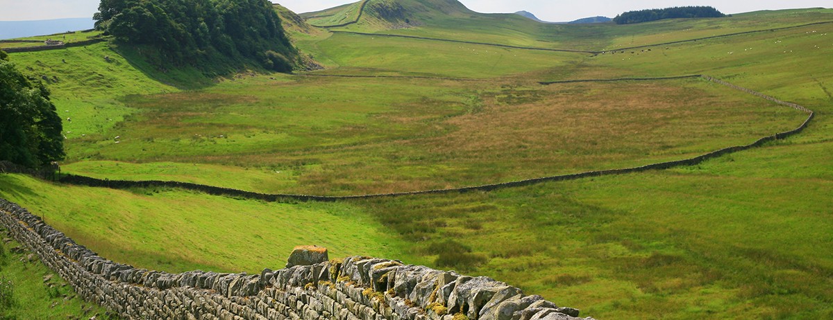
The best remains and the nicest scenery are found in the Northumberland National Park and in Cumbria - the central and Western parts of the route.
Click the blue 'BOOK MY LUGGAGE' button above to organise baggage transfer services.
Walkers are required to bring their own face mask and hand gel.
From the tourist information in Wallsend, by the Swan Hunter Ship Yard, the trail heads out following the walls of the ancient Roman fort of Segedunum. Take the Fossway through Walker and Byker. There can be very busy traffic along Shields Road, until there is the opportunity to drop down to the Tyne river via ‘Broad Chare’ road for a vista of the elegant Tyne bridges, and of the Newcastle skyline. There should be time to climb up to Newcastle Keep. Walk out of the city by the built-up banks of the River Tyne. Cross the busy A69 and then the Western Newcastle bypass and continue through Newburn, before steeply ascending from the river with the countryside about to open up. You enter Northumberland - continue to the first substantial section of the wall just before reaching Heddon-on-the-Wall.
The route follows the B6318 out of Heddon, crosses the A69, then follows the waymarked trail, sometimes in the Vallum ditch, and beside the road, with only minor deviations all the way to Chollerford. There are nevertheless some interesting things to see - remains of Vindobala Roman Fort, The Welton Reservoirs, with beautiful associated meadows which in spring have many flowers, the site of Halton Castle, the field patterns in the fields nearby, and there is the battle site of heaven field. Won by Oswald, King of Northumbria, against forces sent from Wales and the English Midlands. You then come into Chollerford and Humshaugh - areas for accommodation.
Follow the road as above, turning off at Rudchester farm, away from the wall line for the next 11 miles, through Horsley and then finally across the fields, entering woods to cross the Whittle dene. Cross fields and minor roads, zig-zagging across the landscape until rolling onto the old Newcastle road and into Corbridge, with the interesting remains of Corstopitum Roman Fort at the intersection of what was Dere Street, the Roman Road. Reach the pretty village of Corbridge, then crossing the Tyne the trail heads to Dilston, going over the railway line and on through the forests of Park Wood, past the Duke's House in all its neo-gothic glory. Then it is down through Spruce and Larch into the old market town of Hexham, a great place to pause if you are not staying here. It has a famous market place and Abbey, lots of beer & good views from the Tyne. From Hexham, either stay the night, or walk, or take a taxi the five miles to Chollerford to continue the wall walk. Cross over the Tyne, continuing via minor roads through the former pit village of Acomb and re-join the line of Hadrian's Wall a mile before Chollerford, which we reach once again on the B6318 military road.
Next it is on through Chollerford, still on the road as far as Fozy Moss, where the road veers off the wall as it reaches the crags of the Whin Sill Escarpment. The stage roller-coasters to Housteads, with its famed fort and English Heritage museum. There are excellent views over what Richards calls the ‘Northward Tynescape’ to the Bellingham and Simonside Hills. Now follows arguably the most scenic section of the trip, over Highshield Crags and then down via Peel Crags to the National Park car park at Steel Rigg, from where you can walk out to accommodation at Once Brewed.
The wall climbs to its highest point over Winshields Crags, before descending to the delightfully named Bogle Hole. Continue through Thorny Doors and up Cawfields Crags with excellent views onto the Pennines. The path passes by Great Chesters and Magnis (Roman forts), passing Greenhead, the ruin of Thirlwall Castle and, in another mile or so, crosses the Cumbria/Northumberland border on the River Irthing at Gilsand (possibility of accommodation). Interesting Roman defences are found at Birdoswald, and eventually after a trek to Banks, you will find a shop. However, it is another three miles of some of the best cross-country walking of the entire trek before you reach Walton. The pretty little town of Brampton is the obvious place for accommodation around here, but this is two miles off the route.
The route continues undulating across country, passing Castlesteads House, crossing the Cam Beck, briefly joining the road at Newtown before skipping across the fields, and once again after a few miles you join minor roads, crossing the M6 and on via Rickerby into Carlisle on quieter tracks by the beautiful River Eden. This is a very interesting, historic city and has good transport connections if you have to leave at this point.
From Carlisle the Wall Walk follows the Cumbrian Coastal Footpath, firstly out of the defunct industrial suburbs of the town. The trail follows the Eden once again, more or less parallel with the line of the Wall and Vallum, through Grinsdale and Beaumont where you at last veer away from the Eden. You get good views from just north of the village to the peaks of Skiddaw and High Pike to the south and across the Solway Firth to the west. Through Burgh-by-Sands, a short detour takes you to the point on the marsh where Edward I died in 1307. In the vicinity of Dykesfield House, the trail joins an old railway embankment for a couple of miles before re-joining the line of the Wall near Glasson. From here the route follows the minor road to Bowness on Solway, the site of the Roman fort of Maia and journey's end.
Click the blue 'BOOK MY LUGGAGE' button above to organise baggage transfer services.
Carlisle and Newcastle are on the main transport links. Travel from Newcastle by bus to Wallsend and at the end of your walk catch a taxi back to Carlisle. Refer to www.nationalrail.co.uk
Hadrian's Wall Bus - Approximately follows the length of the central part of the wall each day in both directions daily. The Hadrian’s Wall Bus (AD122) is expected to run from the beginning of April to the end of September. It runs between Wallsend, Newcastle, Carlisle and Bowness-on-Solway and stopping at visitor attractions, towns and villages along the way. The AD122 bus goes via Hexham, Chesters, Housesteads, Once Brewed, Vindolanda, Twice Brewed, Haltwhistle, to the Roman Army Museum at Walltown. You can phone 01434 322002 (Not open on Sundays or Bank Holidays) for details of the service. In very severe weather conditions please also contact them or the Traveline on 0871 200 2233.

