Walking through many picturesque villages from the beautiful Cotswold town of Chipping Campden to the World Heritage City of Bath.
Luggage will be collected from 9am and delivered by 6pm. For Bath, due to pedestrianisation and new traffic management processes introduced in Bath in 2020, we now guarantee bags by 6.30pm.
Book your full Cotswold Way package now.
If you have any queries, please email info@sherpavan.com.
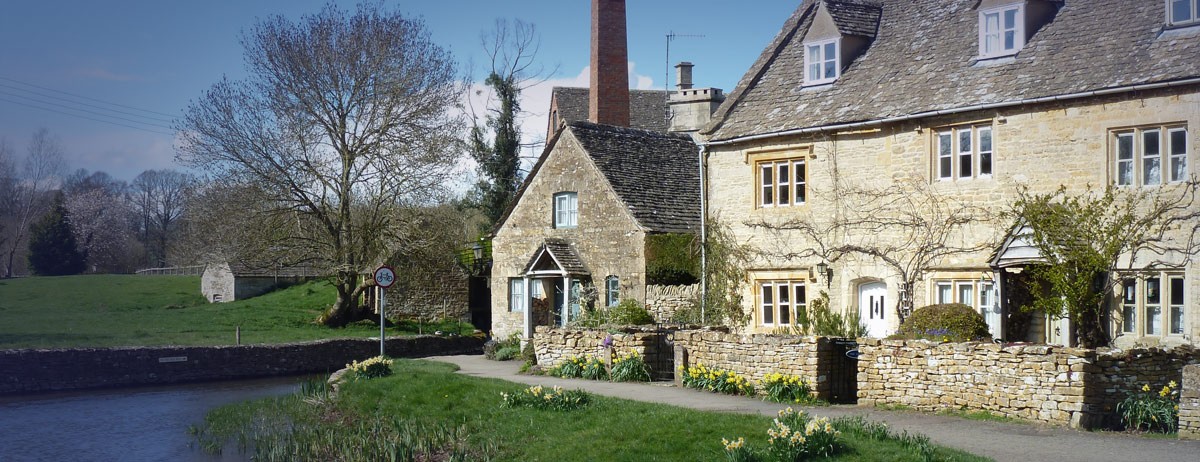
The Cotswolds are hilly rather than mountainous - the highest point being little more than 1,000 feet above sea level. Officially designated as an Area of Outstanding Natural Beauty, the Cotswold landscape is an entrancing mixture of parkland, cultivated fields with dry-stone walls of jurassic limestone, and patches of unspoiled woodland. Stone-built also are almost all of the cottages, farmhouses, villages, and small towns that the route passes. The Cotswold Way is also a walk through English history, passing prehistoric hill forts, ancient burial barrows, Saxon and Civil War battle sites, as well as fine stately homes.
The Cotswolds became wealthy during the 17th century, due to the wool trade, and the fine stone houses and churches are a symbol of that era. The industrial revolution seemed to bypass the region, and the Cotswolds today are still a very affluent part of Britain.
Click the blue 'BOOK MY LUGGAGE' button above to organise baggage transfer services.
Walkers are required to bring their own face mask and hand gel.
The Cotswold Way begins in one of the area’s finest villages, and then embarks on probably its most challenging section. Impressive views from the top of the escarpment are interspersed with delightful villages at its foot and there is a wealth of history and interest throughout. Refreshments are readily available, with plenty of tea rooms and inns in Broadway, a fine village inn in Stanton serving lunch from 12pm to 2pm and a farm shop tea room at Hailes. There are also several shops in Chipping Campden where you can a picnic lunch, with an official picnic site at Fish Hill, and other good places to stop on each hilltop in fine weather.
A day of contrasts that takes you across the wildest part of the Way on Cleeve Common, then skirts around the largest town along the route, Cheltenham. After a long climb from Winchcombe, the Way stays mostly at high level before crossing the valley of the River Chelt. Refreshments are served at the golf club on Cleeve Hill and at a couple of inns nearby. Winchcombe has plenty of shops for picnic supplies and there are numerous pleasant places to stop in fine weather. There is a good selection of accommodation available on the outskirts of Cheltenham, a short distance from the Way, throughout the last part of this section.
This section follows the top of the escarpment, with regular shorter hills replacing the long climbs of the earlier stages. It takes you across open grass and farmland and through glorious beech woods, passing an amazing collection of archaeological sites along the way. For lunch the Air Balloon Inn near Barrow Wake serves food all day, as does the Royal William on the way to Painswick Beacon. You will find picnic tables at Crickley Hill and other pleasant spots on Leckhampton Hill, Barrow Wake and in Cranham Woods.
More wide views and longer hills again today as the Way crosses the valley of the River Frome. This, unusually for the Cotswolds, breaks through the escarpment to flow west into the Severn, creating impressive slopes of hanging beech woods. The hills above are rich with hill forts and burial mounds but refreshment stops are rather scarce, with just one inn on the route at Edge and others just off it in Westrip, Kings Stanley and Nympsfield. There are shops for packed lunch supplies in Painswick or, with a short diversion, in Ebley near Rye Ford and Kings Stanley. The only official picnic site is at Coaley Peak but you will find other nice places at Hares Field Beacon, Standish Wood and Stanley Wood.
A short day and a chance for a bit of a breather, although you still have a few hills to negotiate. You can use the extra time to explore the ramparts of Uley Bury and the old cloth-weaving town of Dursley, or pause for thought at the Tyndale Monument. Refreshments and shops are readily available in Dursley and you can get lunch between 12pm and 2pm at the Black Horse in North Nibley. You can get supplies at the start in the Uley, and there are plenty of scenic, though rather exposed, spots to stop for a picnic around Stinchcombe Hill.
After the climb out of Wotton it is generally easier gradients on this stage. There are no inns actually on the Way before Old Sodbury, but short detours will take you to village pubs in Hillesley, just beyond Alderley, and in Hawkesbury Upton. There is also little open ground along this section, with the Way following tracks, lanes and field paths - so opportunities for picnic stops are limited. The best places are probably the woods above Long Coombe on the way to Hawkesbury or by the attractive pond in the village. Old Sodbury Hill Fort is a scenic stop later on in the walk. There are plenty of shops in Wotton at the start, which are a better bet than the few village shops along the route, which have less regular opening hours. It may be worth getting two days supplies, as the opportunities are also limited tomorrow.
Shorter climbs are followed by the long descent into Bath. The first part crosses the A46 several times, and the M5, but also takes you off on pleasant field walks along the hillsides below Dyrham Park. The second half takes you up onto Lansdown, site of a Civil War battle and one of the country's highest racecourses, offering wide views over the World Heritage City of Bath. As you walk into the city, beautiful parks and the sweep of Georgian crescents replace the open countryside. After an official picnic site before Dyrham, there are inns at Pennsylvania (where you can also get provisions), and Cold Ashton - and other nice spots to stop at Little Down and Penn Hill.
Click the blue 'BOOK MY LUGGAGE' button above to organise baggage transfer services.
The Cotswolds are well-served by train services from London and other major cities to Cheltenham or Oxford. From here, you can take a bus, or a taxi to Chipping Campden where the walk starts. At the end of the walk, Bath has excellent rail and coach connections to many of the UK’s major cities. Refer to www.nationalrail.co.uk
National Express offer coach services from central London, and Heathrow and Gatwick airports, to Cheltenham and Oxford. You can also take the coach from Bath back to London, and other major cities, at the end of the walk. Refer to www.nationalexpress.com
London Heathrow is the most convenient airport for the Cotswolds, but you can also fly into London Gatwick or Birmingham International.

